| Resource Maps for the Nashville City Cemetery
There are two maps available to assist in finding the gravesite you are researching. |
|
| In 2002, Susan Finger, MTSU Geosciences graduate student, completed a numbering system for all tombstones in the City Cemetery. Each tombstone was assigned an ID number. In 2005, Metro Historical Commission (MHC) contracted with Hart Freeland Roberts, Engineers, to draft plats showing the precise location of tombstones and additional permanent cemetery features, such as stone curbs & fences. Fred Zahn, MHC staff member, merged the numbering system with the Hart Freeland Roberts plats and created the City Cemetery Survey Maps 2005. The maps are designed in layers to show landscaping and other features that have been hidden in this graphic to allow clearer access to the ID numbers. |
2005 Map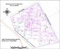 Click to Enlarge |
|
|
|
|
1908 Map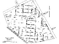 Click to Enlarge Mapproduced in 1908 with names of those |
| CLICK HERE to view photo of original 1908 map in the collection of the Metropolitan Archives Also visit 1909 Alphabetical List of Dead in City Cemetery. |
|
|
|
|
